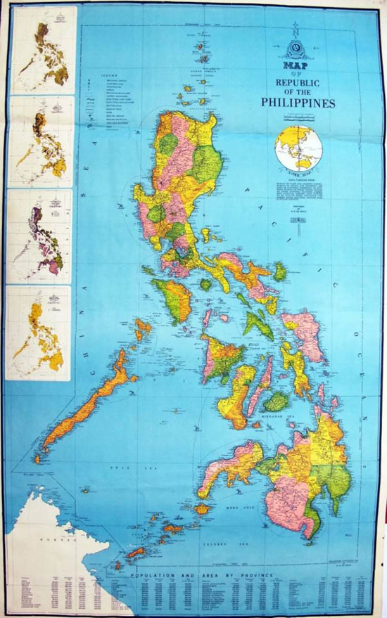
Map of Republic of the Philippines was printed by the Government of the Philippines in 1961. The data in the map can be justifiably called rich and comprehensive in that they came from the Coastal Geodetic Bureau, the Census Bureau, the Library of Congress, the Election Commission, the Public Affairs Bureau, the Land Board, the National Planning Commission, the National Library, insurance companies, banks, etc., with reference to privately prepared maps, the data of real-estate brokers, personal files and visual investigations. Preparation by D.D.DE JESUS guaranteed its authority as an official map of the country. In this color map, a circular line was drawn around the Philippine Islands, with the annotation "International Treaty Limit" to indicate its status as the boundary of the Philippines established in accordance with international treaties. The western boundary of this line coincides with the 118° east longitude line. To the west of the line, four topographies were found from top to bottom, including Philippine topography, Philippine population map, Philippine climate map, and Philippine hydroelectric pump irrigation map. Huangyan Dao was not marked on the map, indicating that it did not belong to the Philippines.

Map of Republic of the Philippines


 Overview
 Resources & Environment


 QQ 好友
QQ 好友 微信好友
微信好友 易信好友
易信好友 QQ空间
QQ空间 朋友圈
朋友圈 百度空间
百度空间